| Measure | Value (anomaly) | Time |
Month cumul. | Record High | Record Low |
| Minimum Temperature |
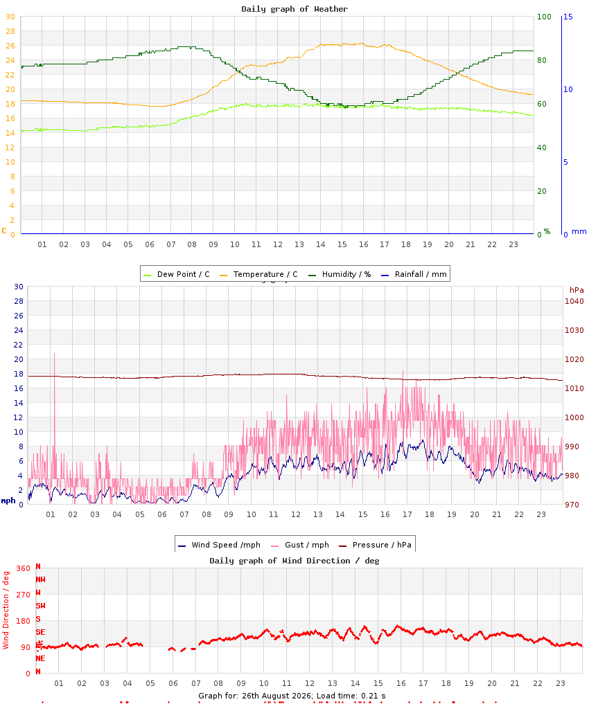
18.8 °C (+5.4) |
03:19 |
15.3 °C (+1.1) |
18.8 °C (+5.4), 2026 |
10.5 °C (-2.9), 2014 |
| Maximum Temperature |
25.1 °C (+3.4) |
17:08 |
27.2 °C (+4.7) |
31.7 °C (+10.0), 2019 |
17.3 °C (-4.4), 2010 |
| Mean Temperature |
20.7 °C (+4.4) |
|
21.3 °C (+2.9) |
24.1 °C, 2019 |
14.0 °C, 2010 |
| Minimum Humidity |
61% |
17:28 |
38% |
70%, 2020 |
39%, 2019 |
| Maximum Humidity |
90% |
07:57 |
79% |
98%, 2010 |
73%, 2017 |
| Mean Humidity |
79% |
|
59% |
85%, 2010 |
58%, 2017 |
| Minimum Pressure |
1008 hPa |
17:05 |
1015 hPa |
1023 hPa, 2021 |
1002 hPa, 2020 |
| Maximum Pressure |
1013 hPa |
00:21 |
1020 hPa |
1026 hPa, 2021 |
1009 hPa, 2025 |
| Mean Pressure |
1010 hPa |
|
1018 hPa |
1024 hPa, 2021 |
1007 hPa, 2025 |
| Mean Wind Speed |
3.2 mph (-0.8) |
|
3.9 mph (-0.1) |
6.3 mph, 2025 |
1.4 mph, 2017 |
| Maximum Wind Speed |
11.2 mph |
17:33 |
12.3 mph |
20.4 mph, 2025 |
6.1 mph, 2017 |
| Maximum Gust |
16.1 mph |
16:52 |
19.1 mph |
32.3 mph, 2025 |
9.4 mph, 2017 |
| Mean Wind Direction |
S |
|
|
|
|
| Rainfall |
4.4 mm |
|
6.4 mm (14%) |
4.8 mm, 2020 |
|
| Maximum Hourly Rain |
1.8 mm |
06:27 |
|
2.6 mm, 2025 |
|
| Maximum 10-min Rain |
0.8 mm |
05:49 |
|
2.4 mm, 2025 |
|
| Maximum Rain Rate |
3.6 mm/h |
06:48 |
|
42 mm/h, 2015 |
|
| Minimum Dew Point |
13.4 °C |
21:21 |
9.5 °C |
14.0 °C, 2019 |
6.4 °C, 2013 |
| Maximum Dew Point |
19.1 °C |
14:45 |
14.7 °C |
19.1 °C, 2026 |
12.8 °C, 2011 |
| Mean Dew Point |
16.7 °C |
|
12.2 °C |
16.7 °C, 2026 |
10.5 °C, 2013 |
| Measure | Value | Time |
Month cumul. | Record High | Record Low |
| Night Minimum (21-09) |
18.8 °C |
02:56 |
15.3 °C |
18.8 °C, 2026 |
10.5 °C, 2014 |
| Day Maximum (09-21) |
25.1 °C |
17:08 |
27.2 °C |
31.7 °C, 2019 |
17.3 °C, 2010 |
| Max 10m Temp Rise |
0.6 °C |
15:33 |
0.8 °C |
0.9 °C, 2022 |
0.4 °C, 2015 |
| Max 1hr Temp Rise |
2.0 °C |
13:35 |
3.0 °C |
3.6 °C, 2019 |
1.6 °C, 2010 |
| Max 1hr Hum Rise |
6% |
23:11 |
12% |
16%, 2019 |
4%, 2018 |
| Max 10m Temp Fall |
0.4 °C |
17:47 |
0.7 °C |
0.7 °C, 2013 |
0.2 °C, 2014 |
| Max 1hr Temp Fall |
1.6 °C |
18:35 |
2.4 °C |
3.5 °C, 2017 |
0.8 °C, 2014 |
| Max 1hr Hum Fall |
11% |
13:15 |
12% |
18%, 2014 |
6%, 2017 |
| Max 10m Wind Speed |
8.7 mph |
17:41 |
9.0 mph |
13.3 mph, 2025 |
4.2 mph, 2017 |
| Minimum Feels-like |
22.8 °C |
23:57 |
17.1 °C |
22.8 °C, 2026 |
11.5 °C, 2014 |
| Maximum Feels-like |
30.7 °C |
15:33 |
29.9 °C |
37.9 °C, 2019 |
19.1 °C, 2010 |
| Mean Feels-like |
25.8 °C |
|
23.8 °C |
29.0 °C, 2019 |
15.8 °C, 2011 |
| Air-frost Hrs |
0 hrs |
|
0 hrs |
0 hrs, 2009 |
0 hrs, 2009 |
| Minimum PM2.5 |
2 |
23:50 |
3 |
2, 2026 |
0, 2021 |
| Maximum PM2.5 |
44 |
03:30 |
14 |
44, 2026 |
44, 2026 |
| Mean PM2.5 |
16 |
|
7 |
16, 2026 |
16, 2026 |
| Measure | Value (anomaly) |
Month cumul. | Record High | Record Low |
| Temperature Range |
6.3 °C (-2.0) |
12.0 °C (+3.5) |
15.6 °C (+7.2), 2019 |
4.7 °C (-3.6), 2020 |
| Humidity Range |
29% |
41% |
52%, 2013 |
24%, 2020 |
| Pressure Range |
4 hPa |
5 hPa |
17 hPa, 2020 |
3 hPa, 2022 |
| Measure | Value [% of max] |
Month cumul. | Record High | Record Low |
| Sun Hours |
0 [0%] | 261 hrs (161%) [72%] |
11.5 [91%], 2019 |
0 [0%], 2026 |
| Wet Hours |
6
[Mean rain rate: 0.7 mm/h] | 11 hrs (33%) [1.7%] |
7, 2010 |
0, 2009 |
| Cloud Cover |
unknown |
| Events |
None |
| Comments |
data is awaiting quality control from site operator |
| Extra Comments |
|
| Issues |
None known |
| Observer Absent? |
Yes - observations may be unreliable |
| Pond Temperature @ Hampstead Heath |
19.5 °C |



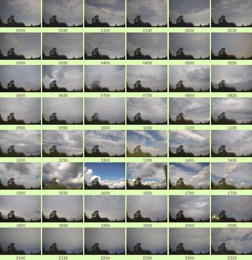 Full resolution individual images at up-to 5 minute intervals